Showing posts with label Mississippi River. Show all posts

Friday, February 3, 2023

Mudlarking On The Mississippi

 Ever heard the term mudlarking? If you’ve talked very much with me, you know that mudlarking, or beach-walking-looking-for-treasures is one of my favorite activities. I’ve been a beachcomber all my life and just recently learned about mudlarking. Nicola White has a YouTube channel showing her walking along the Thames foreshore in London at low tide and finding wonderful and interesting things, some even dating back to Roman times. I’m hooked on her posts.

 So of course on my cruise I looked for opportunities to walk along the Mississippi and see what I might find. The river is at a 40-year low which means lots of beach was exposed that hasn’t been in 40 years. When our ship was moored just below the St. Louis Arch I couldn't wait to get off and go mudlarking! I did pick up some interesting glass and other stuff and did create a window-art piece with it.... here are my finds in the raw (laid out on a daily bulletin on the ship): 

 It was here that I found my biggest find!  The bottom of a ceramic or clay beer bottle dating to the 1850s from a brewery in Wisconsin! I didn’t keep it but gave it to Aaron, our history presenter on the ship, and he documented it for me. But it was such fun to find something that old and hold it in my hand.

What else do beachcombers and mudlarkers find? Anything that’s been tossed into the river or ocean or lost into the same. One can find coins, toys, jewelry, nails, tools, broken glass, pieces of dishes, etc. The best thing about Nicola’s presentations (on YouTube, remember) is that if there is an inscription on her find, she does the history of that piece and perhaps how it came to be in the Thames mud. 

Have you time in your life for a new hobby? Come mudlark with me!

Thursday, February 2, 2023

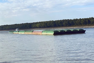
Mississippi River Shores & Barges


Nauvoo, Illinois, at 2:00am; I am a member of the Church of Jesus Christ of Latter-day Saints, and I did SO want to see Nauvoo and hopefully the Nauvoo Temple. I was blessed to be on the correct side of the ship and to wake up just in time to see the shining lights of the Nauvoo Temple. One of the small "warm fuzzies" that happened on this wonderful trip.

I naively imagined that there would be towns or cities or ports or LIGHTS all along the river. Not so at all. Since Mother Nature is in control of the meandering Mississippi, the channels are like braided ribbons, miles wide. Because of this, nothing permanent is built right on the river’s banks. Made sense. So it was pitch-black-dark at night most of the way. (Except when, above St. Louis, we would enter a lock at night and everything was brightly lighted.)

The Mississippi flows just under 1800 miles from St. Paul to New Orleans, and falls 450’ in elevation from St. Paul to St. Louis; the 28 locks and dams on the upper river (above St. Louis) were constructed to control the river and keep the water where farmers needed and wanted it. Most of the locks are quite shallow, under 11’. Exception is the one at Keokuk at 38’. Some 60% of American exported grain comes down the Mississippi. One barge can carry more than 70 trucks or 16 train cars; by water is the most efficient way to ship grain. In October 2022, we saw barges half empty so as to rise higher above the bottom and not get stuck.

The Mississippi is really many rivers in one. First part is the headwaters above St. Paul; no boats allowed on this part. Next is the St. Paul to St. Louis, with those 28 dams and locks. Third is St. Louis to Cairo (KAY-row); fourth is Cairo to Baton Rouge. Last is the Baton Rouge to New Orleans section of the river.  Our teacher that day characterized the lower Mississippi as a “huge parking lot of ships and barges with a stream running through it.”

Those states having  boundaries along the Mississippi have seen their boundaries changed over the years due to three factors: (1) Mother Nature, ribboning the river all across the miles wide area between the hills; (2) Corps of Engineers working since 1824 to control the river and straighten out crooked or tight bends; (3) Civil War.

More Jeopardy fodder for you, no?

Mississippi River Locks & Dams

 Without dams and locks the Mississippi River would be un-navigable to ships and barges and the states along the river would be continually flooded and their boundaries changed by the meandering river.  Locks and dams are vital to travel and commerce on the Mississippi.


There are 28 locks between St. Paul and St. Louis; there are none below St. Louis. The Mississippi River falls 450-feet between those two cities. Most locks are really shallow, under eleven feet. The largest/deepest lock is at Keokuk, Iowa and is 38-feet deep. (The Mississippi is not a very deep river.) 


The top photo (from Google) shows a dam and lock. As we approached a lock during the night (and this was often the case above St.Louis), the area was flooded with light for navigating into these narrow channels. This maneuver takes knowledge and skill.  The ship enters; the gates behind the ship close; the area fills with river water and when the ship is raised or lowered to the desired level, the front gate is open and the ship proceeds. Not just ships but these HUGE barges too. All us passengers stood on deck (during the day) and watched; it was fascinating. 


The lower photo shows how close we were to the lock walls....that's my hand reaching out. Illegally, as I found out later. 

Wednesday, February 1, 2023

Eagles On The Mississippi Flyway


According to Aaron, our education presenter on the cruise, the Mississippi River valley is a major fly path for many eagles (and other birds). While they can be seen in almost all states, they are predominately in Alaska, Minnesota and Wisconsin. Here is some Upper Mississippi River eagle trivia (compiled by me and I hope I jotted down the facts correctly):

  • An eagle's head stays dark until age 5.
  • In the early 70s, DDT nearly decimated the eagle population. 
  • When only one nest could be found (by boat/survey between St. Paul and St. Louis) a loud alarm was raised and finally in 1973 DDT was banned.  
  • Unless you are Native American, it is illegal to own any part of an American Bald Eagle. 
  • Eagles mate for life; they lay 1-3 eggs per year with only a 50% survival rate. 
  • Eaglets fledge in 8-12 weeks. 
  • Nests can be as big and heavy as a VW bug!  And are used year after year.
  • Eagles only weigh 7-8 pounds and have a 6-8 foot wingspan. They can turn their heads 180o. 
  • Females are 1/3 larger than males.
  • The name "bald" comes from an Old English word meaning white.
  • Why is this our national bird? And not the turkey (as Benjamin Franklin lobbied for)? It was decided that an eagle symbol was more militant and a turkey was, well.... a turkey. 
  • They can live 18-20 years in the wild but twice that long in captivity. 
  • Their "eagle eyes" can spot a  hopping rabbit 3 miles away. 
  • The Upper Mississippi River is prime habitat for Bald Eagles.... lots of trees to the shore line, lots of islands. 
  • Eagles eat mostly fish; their talons are as big as a man's hand. 

One does not need to be a card-carrying bird watcher to appreciate our American Bald Eagle. Out on the top deck of our ship, it was fun to look for and spot eagles with other passengers. We were all appreciative and in awe.