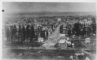
Why was Spokane first settled along the river, east to west through what's now downtown? There was a simple reason in those early days: the south hill. A couple of years ago, Lynn Krogh and I enjoyed a Southside Community Center's history tour led by Richard Sola. Here is some of what we learned that day:
There were some 50,000 people in Spokane by 1900. They mainly arrived on the railroad. They settled east to west in the valley because the south hill was a real barrier to growth. There was no way to get up the basalt-formation hills until roads were cleared and especially until the streetcars arrived. There were bridges across the Spokane River to access the north side and so settlement first spread north.
Geologically, Dr. Sola taught, is that the Dishman Hills is the original seashore boundary (where the Pacific plate subducts). The several Ice Age Floods bypassed this area to it kept its good soil and was perfect for agriculture.
The first whites in the area were the fur traders; very few came between 1830 and 1870 because there was no easy way to get here except on the trail up from Walla Walla (which is why these towns south were settled before Spokane).
Today we think nothing of the rather steep drive south up the Monroe Street hill (except when its icy!) but yesterday that incline was considered nigh onto impassable.... until it was not.
Other Washington cities have had their steep road problems. Consider the massive regrading project in Seattle:
Quoting from Wikipedia: "Seattle's first 58 regrades "consisted largely of cutting the tops off high places and dumping the dirt into low places and onto the beach".[4] The most dramatic result of this was along that former beach, filling the land that constitutes today's Central Waterfront. Today's Western Avenue and Alaskan Way lie on this landfill.[4]"
I do suggest that you click to Wikipedia to read the rest of the story about
the regrading of Seattle's hills.


No comments:
Post a Comment